Monday, April 2, 2012

Carson Falls - Marin Waterfall Hike - 4/2/12

Carson Falls

          The sun was shining when I left work in Berkeley and headed for the hills of Marin to unwind and do some adventuring. Driving past Fairfax and the Alpine Club I parked at the base of Azalea Hill and the Pine Mountain Fire Road where there were only a couple other cars in the dirt lot. On weekends it can be quite a zoo unless you arrive really early.
          The smell of blooming Ceonothus enveloped me as I started out on the Pine Mtn. Fire Road. A Red Tailed Hawk circled above while I made way along the first undulating fire road segment. The first few minutes of fairly level terrain are a great warm up before the climbing begins in earnest. As the trail climbs toward the Cypress Forest on top of San Geronimo Ridge the terrain is extremely rough and rocky consisting largely of serpentine outcroppings. It makes for one heck of a climb on a mountain bike I can tell you that.
          Near the top of the first climb, about a mile from the parking lot, is the turnoff for Oat Hill Fire Road which follows a ridgeline heading south to its terminus at Oat Hill overlook. I took the Oat Hill turnoff and descended along the ridgeline and stopped briefly at the top of the Carson Falls Trail to admire the views around me. I had left work in the bustling city of Berkeley just an hour prior and now found myself a world away, immersed in a habitat much more to my liking.
          Within the past few years a new trail has been built to reach Carson Falls as the old one has been retired. Although the old trail descended through open grassland offering views down the Little Carson Valley; It was far too steep for the meadow grasses to withstand the erosion. The newly built trail has many switchbacks and is built on sturdier soil beneath a forest canopy and with proper maintenance should stand the test of time.
          While descending I kept my eyes out for creeping poison oak vines that were occasionally hanging out over the edge of the trail. Within a few minutes I was at the bottom of the valley where I crossed paths with the last hikers as they were leaving the falls. I would now have the place to myself for the rest of the evening.
          Carson Falls is really a series of waterfalls with magnificent pools along the top tiers and one long final plunge at the end. I started by crossing the creek above the falls via a footbridge and then descending along the far side of the creek toward the very bottom pool which resides in the deep shade.
          The riparian habitat at the base of the falls is thick and tough to navigate but I managed to find a couple of vantage points without having to crawl through any poison oak.

Carson Falls Mist Zone

Carson Falls Lower Tier

          While making my way back up towards the upper tiers I stumbled across a few camouflaged Fritillaria.

Checker Lily (Fritillaria affinis)

          Beside the top tiers I relaxed and waited for the sun to dip behind the ridge so I could have better lighting on the falls. I was extra careful not to disturb the precious creek where Foothill Yellow-Legged Frogs lay their eggs during the spring.
          As with most of my visits to Carson Falls and after careful observation, I was rewarded with a view of one of the rare frogs clinging to a rock beside the creek.

Foothill Yellow-Legged Frog (Rana boylii

          A State species of special concern the Foothill Yellow-Legged Frogs have disappeared from nearly half of their historic range throughout California and Oregon. Carson Falls happens to be one of the two remaining populations that remain in our area.
          Although never fully safe throughout the year, March through June is the most vulnerable time for the eggs and it is important to keep away from the stream bed during these times so as to protect the eggs and future generations of frogs. Besides human and pet disturbances and damaged eggs the newly hatched tadpoles also face natural predation by other animals such as newts which I saw plenty of. Thankfully the MMWD has started a docent program where on busy weekends docents stand by to engage with and inform the public about the frogs and the importance of keeping pets on a leash. Barriers have also been erected to help prevent people from getting close to the water. These barriers aren’t the prettiest thing to look at and often times interfere with the view of the falls, but this is the growing issue we face as larger populations are drawn towards delicate ecosystems.
          The sun eventually crept behind a ridge and I began taking some photos. I certainly got my workout as I made my way up and down the tiers looking for different compositions.

Upper Carson Falls with Red Larkspur


Upper Carson Falls from main viewing platform

Upper Carson Falls

          After making some images and relaxing I packed up my gear and began my hike out of Little Carson Valley. I was quite ecstatic to have had the place to myself for the entire evening. At the top of the ridge on Oat Hill Road I took a break to admire the shifting clouds and colors above Tomales Bay to the west.

View West from Oat Hill Fire Road

          I contemplated waiting for sunset but didn’t want to push dinner so far out and so started back towards the car. As I approached the final stretches of Fire Road an Osprey soared overhead as if to give me my farewell from my evening on the trails. I paused one last time to take in the fading clouds.

Lone Iris at Sundown


Sunday, April 1, 2012

Kent Trail and Alpine Lake - 4/1/12

          It was a sunny Sunday afternoon when Sarah and I decided to head out to Sky Oaks and the lakes for a short leisurely hike. We parked at the edge of Alpine Lake near the Bon Tempe Dam and set off on the fire road that crosses the dam itself. We made our way across the dam taking notice of the dozen or so cormorants sunning themselves on the boom that stretches across the lake. At the far end of the dam we took a right toward the Kent Trail. Bright and shiny Buttercups as well as a few California Poppies decorated the hillside. The fire road dead ends at Alpine Lake where the Kent Trail begins, closely following the lakeshore.
          We followed the Kent Trail for a little over a mile as it undulates along the shore taking us from beneath the deep shade of Douglas Firs, to open landscapes with serpentine boulders and low growing chaparral. Checker Lilies were inconspicuously blooming along the trailside in places and are easy to miss if you’re not looking hard.
Checker Lilies

          We traveled a little further before venturing out onto a secluded peninsula where we relaxed at the edge of the lake. We enjoyed views out over the lake with Dutchman’s Rock and Liberty Peak in the backdrop.
Alpine Lake

          A red tailed hawk circled above the lake taking advantage of a thermal. We also observed an Osprey dive repeatedly into the water in the same spot again and again with no results. It was flying awkward and I wondered if it was ok.
          We relaxed a bit before heading back towards the Bon Tempe Dam. Right on the side of the trail we noticed a dismembered bird wing still fresh with bloody flesh. It was certainly not there when we passed by an hour earlier and we were curious as to what had happened. Could it have been the wrath of a Cooper’s Hawk?
Dismembered Wing

          We arrived back at the dam where I hiked a little further down the Shadyside Trail while Sarah made her way to the car. Not long after we parted ways Sarah was lucky enough to have an experience with an otter. The otter swam towards her near the spillway and got right out of the water and walked towards her before sliding back into the lake. I’ve never seen an otter in the vicinity of the Fairfax reservoirs and was quite jealous that I missed the opportunity.
          I hiked along the Shadyside trail where Milkmaids and Hounds Tongue bloomed among the shaded forest floor. There were still enough rains to be supporting a variety of fungus including Witches Butter and Orange Peel Fungus. About halfway down the Shadyside Trail I was looking for signs of Coral Root Orchids starting to pop up when I noticed several turrets which are home to the Turret Spider.
Turret

Aerial View of a Turret Spider Burrow

          Turret Spiders are exclusive to California. Northerly facing slopes in the state’s moist woodlands provide the preferable habitat for Turret Spiders. It is believed that females are the respected elders living up to sixteen years, nearly twice as long as their male counterparts. Stir Crazy seems to be an unknown concept to these spiders as they spend nearly their entire life in their burrow with the exception of the males who leave once to search for a mate before dying.
          I tried to coax one of the spiders out using a blade of grass as a decoy without any luck. I’m not sure whether the turrets were empty, or if they just weren’t interested in my spider charming.
          Remembering that Sarah was waiting for me back at the car to have lunch, I jogged back to the trail head. We tailgated at the edge of Alpine Lake watching several Ospreys soaring overhead in search of fish. Meanwhile a fisherman of the humankind had a bit of luck himself as we watched him reel in a large fish.


Wednesday, March 28, 2012

Marin Waterfall Hike - Pacheco Falls - 3/28/12

          When I think of Novato the image of dry rolling hills studded with oaks comes to mind; certainly not verdant canyons filled with cascading waterfalls. However, two seasonal creeks provide steep terrain showcasing a series of fascinating waterfalls. Both Arroyo de San Jose and Pacheco Creeks behold waterfalls that rival the beauty of any in the county.
          The trail begins at the terminus of Pacheco Creek Dr. in the quiet Pacheco Valle neighborhood in Novato. A small path leads away from the road along the creek and into another world. I followed the trail as it climbed gently uphill crisscrossing the creek beneath a stand of bay laurel.
          Several minutes later the trail thinned out significantly as I approached the first of a series of waterfalls. The first waterfall is set a little ways off from the trail deeper in the canyon with picturesque cascades just downstream from the base. You have to cross the creek to see the falls proper.
Lower Cascades


Pacheco Creek Canyon

          Ferns dangled from the steep hillsides swaying with the breeze caused by the falling water. A typical viewing area or platform is vacant from this rugged environment and a fair view of the falls beauty must be earned, especially the tiers farther up the canyon.

Lower Pacheco Falls


Leaving Lower Falls

          Beyond the lower falls I ascended a “goat path”, which traversed precariously close to the edge of the steep canyon embankment. Blue Dicks were in bloom on the dry grassy hillsides as was the occasional iris, most faded to white.

Blue Dick

          The trail continues to climb the extremely erosive hillside before coming to the next waterfall. The second falls are graced with large moss covered boulders strewn about the base. Deeply shaded, the base of the waterfall is starting to get overgrown with bay laurel.

Middle Pacheco Falls


Pacheco Creek Middle Falls


Middle Falls with Emerald Base


Middle Falls viewed from up the hillside

          Further up and off of the trail I could see a potentially gorgeous waterfall largely obscured by poison oak. The poison oak was so thick on the approach I negated my attempt altogether. This hidden fall was actually the bottom tier to an even bigger Upper Falls. I followed the trail up an extremely steep switchback and out into the sun. I was soon looking down on a fine set of falls with scattered buckeye trees grabbing onto the hillsides. From that vantage the gentle stream ahead meandered through a dense cropping of Star Lilies as it approached the brink and plunged downward on its ever quest to reach sea level. I climbed down beside the falls and relaxed, waiting for the sun to set behind the ridge line offering better light for photographs.

Upper Pacheco Falls


Blooming Blue Dicks at the banks of Upper Falls


View from Upper Falls

          As I relaxed, I realized I had enjoyed the entire hike in solitude. What a fine day indeed when one can find isolation at such an energetic place situated so close to the frenzy of civilization.

Upper Pacheco Falls


Wednesday, March 7, 2012

Burrowing Owls - Cesar Chavez Park - 3/7/12

          Cesar Chavez Park in Berkeley happens to be a sought after spot for burrowing owls to spend their winter. The countless ground squirrels and their burrows provide turnkey homes for the migrating owls.
          I’ve spent several of my lunch breaks down at the park looking for the hard to find little critters. Typically you can have good luck near the northeast corner of the park where they’ve put in a special art installation to help protect the owl’s habitat. This year I believe they’ve reported seeing at least four birds at Cesar Chavez and a couple more at the Berkeley Meadow. I’ve been able to locate three of the owls at Cesar Chavez; however, only one of them was positioned for a decent picture.

Burrowing Owl

          Hoping to get some video footage I showed up at Cesar Chavez before sunrise and went looking for the owls near their burrows. I spotted one in the fenced off northeast corner which was too far away for any photos. I didn’t have any luck finding the others and so I enjoyed the sunrise before leaving to go to work.
Sunrise Over the Bay

          As the sun rose, the lookout on Mt. Tamalpais, reflecting the suns rays, lit up like a beacon.

East Peak Reflections

Tuesday, February 28, 2012

Richmond Bridge Sunrise - 2/28/12

          A quick stop off before getting on the Richmond Bridge on my way to work resulted in capturing some images of a stunning sunrise.

Richmond Bridge at Dawn


Neon Rays


Richmond Bridge Twilight


Morning Commute


Rod & Gun Club Pier

          I can't complain about my reverse commute with killer views!

Sunday, February 26, 2012

Point Reyes - Arch Rock to Mt. Wittenberg Hike - 2/26/12

          I left my house fairly early in route to Point Reyes without any particular hike in mind. I stopped by the Bear Valley Visitor Center and was surprised to see that there were only a few parked cars, so I decided to start my hike there. Perhaps the temperature being in the thirties had something to do with the lack of early morning visitors.
          After referring to my map I settled on a loop hike that I had not done since 1998. The loop includes a trip to the top of Mt. Wittenberg and a journey to Arch Rock. This time I decided to hike the loop in the opposite direction as before because I imagined Arch Rock gets popular around mid day. My plan was to get to Arch Rock early and beat the crowds and then climb Mt. Wittenberg before returning to the trailhead. Most people would probably choose to get the uphill out of the way first and then come back on the mellow Bear Valley Trail, so by going the opposite direction I’d likely miss most of the other hikers.
          The Bear Valley Trail is quite possibly the most heavily used and hectic trail in all of Point Reyes. It is a well maintained multi-use fire road open to hikers bikers and equestrians (no horses on weekends or holidays). For this reason, as well as the attraction at the end of the trail at Arch Rock, this trail sees a lot of action.
          From the parking lot I set off along the Bear Valley Trail hiking briskly as the valley acted like a cold sink, trapping the frigid air. At .2 miles I passed the junction with the Mt. Wittenberg trail which I would be returning on roughly 12 miles later.
          The trail parallels a year round creek, winding through a dense forest of Douglas firs choked by a lush carpet of ferns. At around 1.6 miles, after a slight incline, the trail opened up as I arrived at the Divide Meadow. I contemplated taking a break and watching for wildlife, but I knew hoards of hikers would be approaching soon and any rest would sacrifice my solitude. I continued hiking, soon crossing paths with a father and son carrying large packs who said they had spent a cold night up at the Glen Camp.

Shady section of Trail near Coast Creek

          Coast Creek soon comes into view, paralleling the trail all the way to the coast. About a mile and a half from Divide Meadow I came to a large junction and the end of the road for any bicycles. There is a rack provided to lock up bikes which Sarah and I have taken advantage of in the past. Riding out early is a good way to beat the crowds as well, but it is no fun winding your way through the masses of hikers on your way back.
After passing the bike rack the path narrows to an actual trail for the final mile before reaching Arch Rock. I arrived at the overlook at Arch Rock which affords great views of the Point Reyes coastline.

View From Arch Rock Overlook

          Picking my footing carefully I scrambled down a rough use trail leading to a small beach and the Arch of Arch Rock.

Arch Rock


Archway at Arch Rock

          I was happy to see that the tide was low enough for me to cross Coast Creek and pass through the arch to the south side of Kelham Beach. Every other time I’ve been here the tide has prohibited such an exploration. I took off my shoes and stashed them up against the cliffs then took a stroll north along the sandy stretch of beach.
          A magnificent sea stack juts out of the ocean just off shore which held my attention for a while, trying to capture the right image.

Sea Stack Serenity

          The serenity was surreal while it lasted, but before long the first of many hikers were starting to arrive at the overlook above. With several more miles of hiking in front of me I decided to head back through the Arch and continue on my way.

Northside of the Arch

          From the Arch Rock Overlook I backtracked a short distance before breaking off and heading north on the Coast Trail.

View Towards Mt. Wittenberg From Arch Rock

          The Coast Trail remained flat for a half mile before reaching the junction with the Sky Trail where I began climbing in earnest. I followed the switchbacks up the ridge enjoying views of the ocean and various trail side wildflowers.

View of Point Reyes from the Sky Trail

          The Sky Trail takes one through a variety of different ecosystems from open sunny hillsides covered with coyote brush and other shrubs, to the deep shade of the forest with swaths of sword ferns lining the hillside and delicate pink petals emerging from the many flowering currants.

Flowering Currant

          I greatly enjoyed this section of the Sky Trail as I still had the trail to myself, and it gave me the feeling of really being out there. About a mile and a half from the Coast Trail the Baldy Trail appears on your right leading back down to the Bear Valley Trail. Continuing on the Sky Trail, the climbing eases up and the terrain levels a bit while following a ridge line to the next junction with the Old Pine Trail.

Satyr Anglewing

          By this time my stomach was growling and I contemplated stopping for lunch, but the sight of Mt. Wittenberg not far off kept me moving.
          I soon arrived at another junction, this one with the Woodward Valley Trail leading back down to the coast near Coast Camp. The junction is in the middle of a small grassy clearing with the perfect balance of sunlight and tree cover, making it a good resting spot. The summit was calling however and so I left the picturesque setting for more hiking and elevation gain.
          Resuming my summit march I soon passed the Meadow Trail and arrived at an open area with the short but steep path leading to the peak of Mt. Wittenberg. From my past hike I recall the summit not being all that interesting, lacking views and any sense of a summit at all. I made a quick jaunt to the peak nonetheless just to say I did it, and then returned to the open dry meadow-like area just below the summit.

Clearing Below Summit of Mt. Wittenberg

          I sat and enjoyed lunch while taking in views of Point Reyes to the west, though barely visible through the hazy skies.
After lunch I made a quick decent on the Mt. Wittenberg Trail which drops steeply 1.8 miles to the valley floor below. Although steep, the trail is outfitted with many switchbacks and I can happily say I was glad to be going down as opposed to up. At the same time I was nearing the end of my hike and my knees were starting to get soar; the downhill greatly adding to the pain. The switchbacks came to an end and the path let back out onto the Bear Valley Trail where I strolled back to the parking lot among the other intrepid hikers returning from their explorations.


Saturday, February 25, 2012

Muir Beach Sunset - Celestial Alignment - 2/25/12

          After returning from a great trip at Salt Point State Park I was still craving a colorful sunset. Late in the afternoon there was scattered cloud cover in the sky and so I ventured out to Muir Beach to catch sunset. I parked in the bustling dirt lot and set off across Redwood Creek and onto Muir Beach.
          The beach was as busy as usual so I trudged south to the more secluded rocky shoreline where I had the place to myself. I’m sometimes amazed how a place can be so crowded and yet just a few hundred yards away one can find complete isolation.
          I scouted around before settling down a top a rock outcropping and watched as sets of waves rolled in and the sun dipped closer to the horizon.
**
Going... Going


Gone!

          Like Autumn leaves the few remaining wisps of clouds began to change colors. As dusk turned to twilight the clouds continued their transformation until the last hue of pink dissipated into the prevailing darkness.
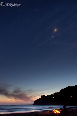
          I hung around for a while as I knew that Jupiter and Venus would be aligning with the Moon, a short lived celestial display lasting only a couple of days, and I hoped to capture an image.

Celestial Surf

          Back at the beach most of the crowds had dispersed apart from a couple of groups gathered around two blazing campfires. I couldn’t resist stopping and warming up my hands as well as firing off a few long exposure frames.

Campfire Stories


Campfire Romance